|
|
|
|
|
| Today's News |
 The
area now comprising district Kotli was a sub-division of Mirpur district up
to the year 1975. Prior to 1947, it was a part of the Jammu area. Kotli is a
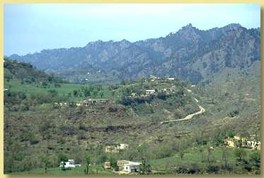
hilly area rising gradually towards the high mountains of Poonch district.
Its climate is more moderate than that of Mirpur due to the sub-mountaneous
topography. The river Poonch passes through Kotli to be joined by a smaller
river called the Baan at Brahli, a short distance from Kotli. The
area now comprising district Kotli was a sub-division of Mirpur district up
to the year 1975. Prior to 1947, it was a part of the Jammu area. Kotli is a
hilly area rising gradually towards the high mountains of Poonch district.
Its climate is more moderate than that of Mirpur due to the sub-mountaneous
topography. The river Poonch passes through Kotli to be joined by a smaller
river called the Baan at Brahli, a short distance from Kotli.
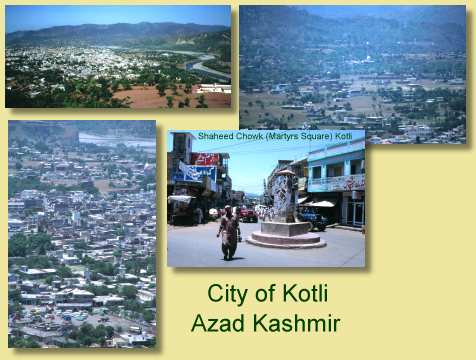
The district headquarter is at a distance of 141Km from Islamabad
(capital of Pakistan). It is linked with Mirpur by two metalled roads, one
via Gulpur and Rajdhani, and the other via Dhungi and Charohi. It is also
directly linked with Islamabad/Rawalpindi via Sehnsa and Holar. Kotli has
basic facilities like a main bazaar, banks, hospitals, colleges, telephone
and telegraph office and hotels.
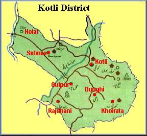
At a distance of 26Km from Kotli via a metalled road lies Tattapani, a popular tourist and mythical destination. Thousands of people flock to the Sulphur Springs each year in the hope to find magical cures for illnesses.
Nakyal was part of Mehndar sub-division before 1947 and is now a sub-division of the Kotli district. Situated at 1524m above sea-level, it is 40Km from Kotli. Going South-East, Khoi Ratta lies 78 Km from Kotli. A vibrant town, at an elevation of 2570 meters above sea-level is most famous for the annual Basakhi (festival). Thousands of people from the Kotli and other adjoining districts flock to the festival in spring to watch sports, animal parades and horticultural displays. The nearby Banah is a beautiful area full of natural springs and waterfalls. At Bahees Naraha several springs emerge from the mountains. This was an important Hindu place of worship in ancient times. Close to Khoi Ratta are the Bagh Fatehpur and Bagh Sain Hazuri which are known for their natural beauty. Thousands of people flock to Mai-ka-Makam Shrine, a distance of 4Km from Khoi Ratta, to pay homage to Mai Toti Sahiba. Khoi Ratta, lying close to the Cease-Fire-Line, has been the victim of agressive firing and shelling by the Indian army in recent years, causing casualties in the military and civil sector. Going on South-West, Gulpur is located on the junction of the
Kotli-Mirpur and Kotli-Rawalpindi road. Gulpur is a small town providing for
the local villages as well as the residents of a large refugee camp. Going West from Gulpur, on the Kotli-Rawalpindi road, Sehnsa lies just before Holar (the boundary point between Azad Kashmir and Pakistan). Sehnsa is a sub-divisional (Thesil) headquarters of Kotli district in the center of Sehnsa valley. It is situated at a distance of 35 Km from Kotli. Nearby is the scenic Bruhian sorrounded by Chir forests and natural beauty.
|
|
|

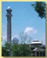 Kotli
is well known for its Mosques and is often referred to as Madina-al-Masajed.
Aghaar Sharif, consisting of a large Mosque and a Shrine (of the late Qazi
Fateh Alam), under the guidance of Hazrat Sahib, is a large complex on the
outskirts of the city. Hazrat Sahib (Sahbzada Mohammed Sadiq) is well known
for building Mosques, Madersas and providing Islamic education and spiritual
guidance throughout the Kotli and Mirpur districts. Hazrat Sahib can only be
seen at the Friday prayers as he is engaged in worship in seclusion at all
other times.
Kotli
is well known for its Mosques and is often referred to as Madina-al-Masajed.
Aghaar Sharif, consisting of a large Mosque and a Shrine (of the late Qazi
Fateh Alam), under the guidance of Hazrat Sahib, is a large complex on the
outskirts of the city. Hazrat Sahib (Sahbzada Mohammed Sadiq) is well known
for building Mosques, Madersas and providing Islamic education and spiritual
guidance throughout the Kotli and Mirpur districts. Hazrat Sahib can only be
seen at the Friday prayers as he is engaged in worship in seclusion at all
other times.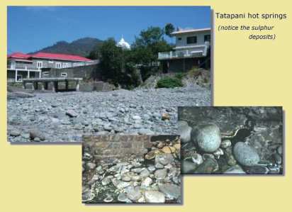
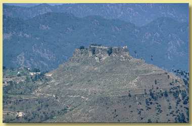 Adjoining Gulpur is Throtchi famous for its castle built in 1460. It
was here in 1947, that a contingent of local men headed by Col. Mahmood
defeated and chased out the Dogra army. The Dogra soldier were beseiged at
the Throtchi Castle until they decided to make a run for Jammu. They were
chased through Changpur and Khawas villages, and some through the Mhooli
river. They were eventually caught up at a place called Dabrian, near Joona,
where a final showdown took place. Many of the Dogra soldiers were killed in
the encounter, whilst one or two who were heavily armed managed to retreat
towards Jammu. Today, the Late Col. Mahmood is regarded as a celebrated hero
and Dabrian is place of national importance.
Adjoining Gulpur is Throtchi famous for its castle built in 1460. It
was here in 1947, that a contingent of local men headed by Col. Mahmood
defeated and chased out the Dogra army. The Dogra soldier were beseiged at
the Throtchi Castle until they decided to make a run for Jammu. They were
chased through Changpur and Khawas villages, and some through the Mhooli
river. They were eventually caught up at a place called Dabrian, near Joona,
where a final showdown took place. Many of the Dogra soldiers were killed in
the encounter, whilst one or two who were heavily armed managed to retreat
towards Jammu. Today, the Late Col. Mahmood is regarded as a celebrated hero
and Dabrian is place of national importance.