|
|
|
|
|
| Today's News |
|
|
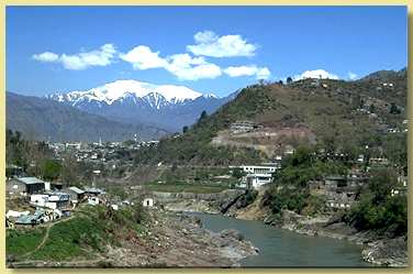 Muzaffarabad,
the capital of Azad Kashmir, is situated on the confluence of the Jhelum and
Neelum rivers. It is at a distance of 138 Km from Rawalpindi/Islamabad
(Pakistan) and about 100 Km from Leepa. Muzaffarabad, once known as Chakrhi
Bahk, derives its present name from Sultan Muzaffar Khan, a chief of the
Bamba Dynasty established in 1662. Cradled by lofty mountains is a complex
of old and new buildings of Muzaffarabad city, cotaining a blend of varied
cultures and languages. There are two historical forts - the Red Fort and
the Black fort situated at the opposite side of the Neelum river. The river
streams proudly through the hubub of the town, joining river Jhelum at Domel
and plays a dominant role in the micro-climate of Muzaffarabad. There are
numerous religious Shrines of Sufi Saints in Muzaffarabad; Shrines of Sakhi
Saheli Sarkar, Shah Anyat Wali and Dhani Mai Sahiba being the most notable. Muzaffarabad,
the capital of Azad Kashmir, is situated on the confluence of the Jhelum and
Neelum rivers. It is at a distance of 138 Km from Rawalpindi/Islamabad
(Pakistan) and about 100 Km from Leepa. Muzaffarabad, once known as Chakrhi
Bahk, derives its present name from Sultan Muzaffar Khan, a chief of the
Bamba Dynasty established in 1662. Cradled by lofty mountains is a complex
of old and new buildings of Muzaffarabad city, cotaining a blend of varied
cultures and languages. There are two historical forts - the Red Fort and
the Black fort situated at the opposite side of the Neelum river. The river
streams proudly through the hubub of the town, joining river Jhelum at Domel
and plays a dominant role in the micro-climate of Muzaffarabad. There are
numerous religious Shrines of Sufi Saints in Muzaffarabad; Shrines of Sakhi
Saheli Sarkar, Shah Anyat Wali and Dhani Mai Sahiba being the most notable.
Pirchinassi - the awe-inspiring locus, with an altitude of 3110m,
it is located 32 Km east of Muzaffarabad. The facinating beauty of the place
wins the admiration of nature lovers. The view of the summit at the
neighbouring mountain peaks spell bounds of tourists. The devotees of Saint
Pirchinassi come in large numbers to pay homage at the Shrine. Athmuqam - is situated at a height of 1371m, it is the sub-divisional headquarters of the area. An attractive place known for its variety of fruit. All neceassary facilities viz bazaar, post office, banks, hospital, telephone exchange are present. Neelum - at a distance of about 9 Km from Athmuqam, Neelum is situated on the right bank of the river Neelum at 1524m above sea-level with facinating scenery.The panaromic lush green valley is profound in fruit and wildlife. Sharda - a breath-taking green spot at an altitude of 1981m. Shardi and Nardi are two mountain peaks overlooking the valley, reputedly named after legendary princess Sharda. It has a captivating landscape with numerous springs and hill-sides covered with trees. On the right bank, opposite Sharda, the Neelum is joined by the Surgan Nallah along which a track leads to Nurinar Pass and through it to the Kaghan Valley. Ruins of an old Buddhist University can also be found in Sharda.
Kel - a small valley situated at a height of 2097m. This is an another picturesque place in the Neelum Valley. The Shounter Nallah joins river Neelum at this place and leads to Gilgit Agency (Northern Areas) over the Shandur Pass at 4420m. Jhelum Valley - the curling Jehlum river passes through from East to West between the high green mountains joining river Neelum at Domel in Muzaffarabad. An artifical lake at Subri was created due to a cloud burst over the sorrounding hill during 1975. Further along the road, 24 Km from Muzaffarabad is located the small town of Ghari Dupata. A further 35Km, lies the famous town of Chakothi. This place sees a large concentration of troops because of the promixity of the Cease-Fire-Line and the constant agression by Indian forces. Other notable places of interst in the valley are Chikar, Loonbagla, Lungian and Danna, all known for their scenic beauty and healthy climate. Leepa Valley - this is the most fascinating valley in Azad
Kashmir. Note: Leepa valley is not open to foreigners as it is the subject of random firing and shelling by Indian troops from across the Cease-Fire-Line. Some villages in this valley cannot even cultivate their land because of indiscriminate firing.
|
|
|

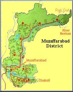 Neelum
Valley - about 200 Km long the picturesque Neelum Valley is situated at
the North & North-East of Muzaffarabad, running parallel to Kaghan Valley.
The two valleys are only separated by snow-covered peaks, some over 4000m
above sea-level. Excellent scenic beauty, panaromic views, towering hills on
both sides of the noisy Neelum river, lush green forests, enchanting streams
and attractive sorroundings make the valley a dream come true.
Neelum
Valley - about 200 Km long the picturesque Neelum Valley is situated at
the North & North-East of Muzaffarabad, running parallel to Kaghan Valley.
The two valleys are only separated by snow-covered peaks, some over 4000m
above sea-level. Excellent scenic beauty, panaromic views, towering hills on
both sides of the noisy Neelum river, lush green forests, enchanting streams
and attractive sorroundings make the valley a dream come true. 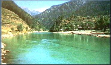
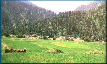 A
fair-weather road branches off for Leepa from Naile 45 Km from Muzaffarabad,
climbs over Reshian Gali at 3200m high and then descends into the Leepa
Valley. It spell-bounds everyone who visists this valley. Dao Khan is well
recognised for its natural beauty and renowned for its calm and peaceful
atomsphere. Deep in the heart of the valley lies Leepa village at 1921m
above sea-level. Its lush green river fields in summer and typical wooden
Kashmiri houses present a wonderful view. Walnut, apples, cherries and honey
of Leepa are very popular.
A
fair-weather road branches off for Leepa from Naile 45 Km from Muzaffarabad,
climbs over Reshian Gali at 3200m high and then descends into the Leepa
Valley. It spell-bounds everyone who visists this valley. Dao Khan is well
recognised for its natural beauty and renowned for its calm and peaceful
atomsphere. Deep in the heart of the valley lies Leepa village at 1921m
above sea-level. Its lush green river fields in summer and typical wooden
Kashmiri houses present a wonderful view. Walnut, apples, cherries and honey
of Leepa are very popular. 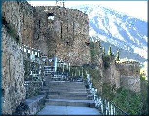 Muzaffarabad
Fort
Muzaffarabad
Fort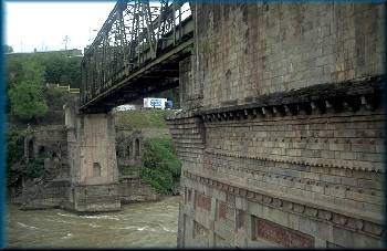 Domel
Bridge-Muzaffarabad
Domel
Bridge-Muzaffarabad